The Turkish
city of Hasankeyf was first inhabited at least 7,000 years before the humans
developed written language. Earlier this year, as Erdoğan fulfilled his 2008 vow to complete the Ilisu
Dam, it was flooded by the waters of the Tigris river.
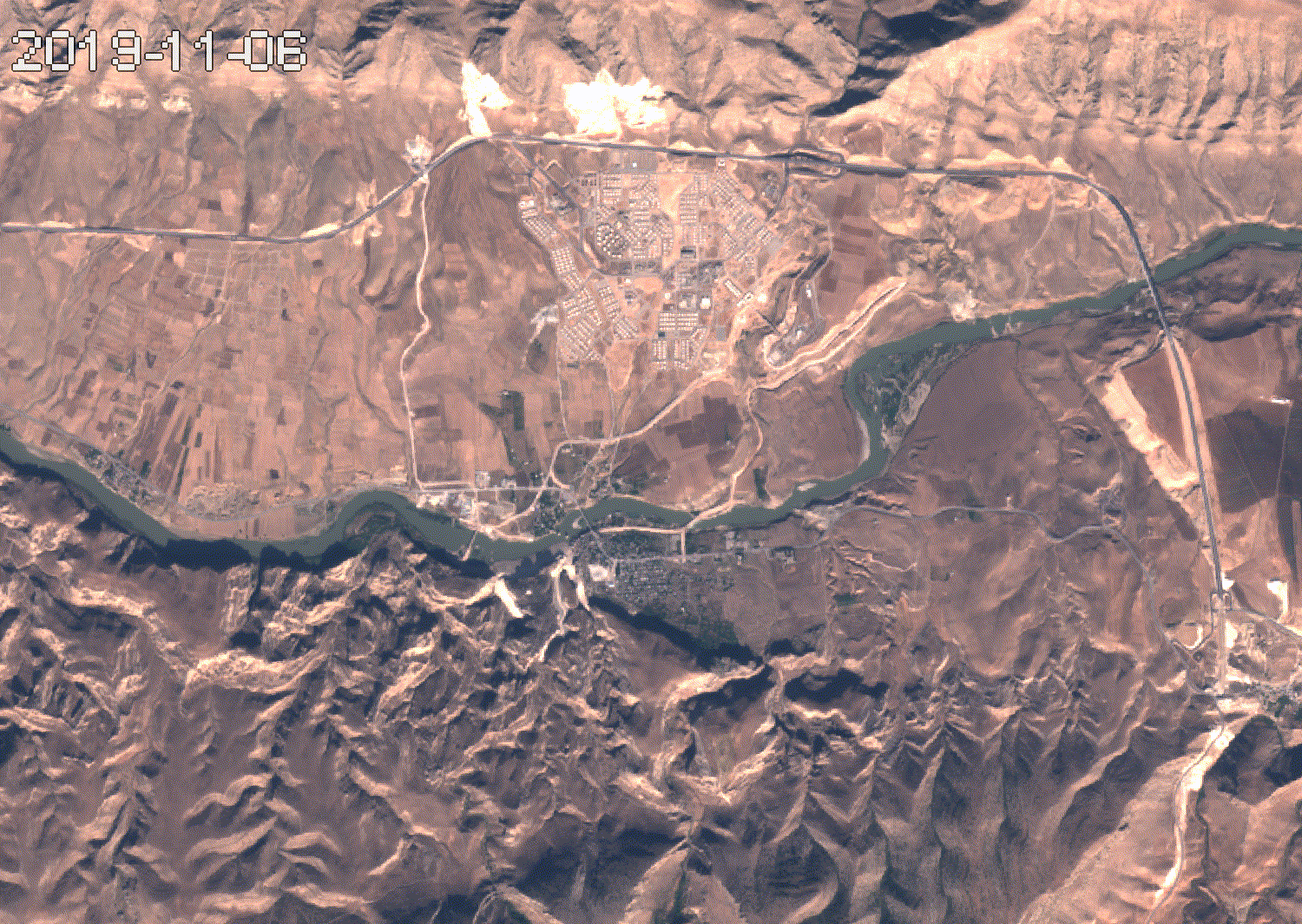
In the timelapse below, Hasankeyf can be seen nestled between the mountains to the south and the
Tigris river. The sprawling development to the north is Yeni Hasankeyf
(New Hasankeyf), a town built to resettle inhabitants of the flooded
city.
|
|
Multispectral timelapse (Sentinel-2) |
"Development from above"
Hasankeyf was flooded by the reservoir of the Ilisu Dam, a component of the Southeastern Anatolia Project (known in Turkey as GAP). This massive regional development program has been underway for over half a century, aiming to build a total of 22 dams, 19 hydroelectric power plants, and irrigate 1.8 million hectares of land. Below, a timelapse shows the Ilisu Dam being completed, and the reservoir being filled.
Hydropower and irrigation are two headline priorities for this project. Unlike its southern neighbours, Turkey does not have significant fossil fuel reserves. This network of dams is thus a critical component of Turkey's efforts to achieve energy independence.
Irrigation also serves a strategic purpose. Southeastern Anatolia is a mainly Kurdish region which has been vying for autonomy since the founding of the Turkish Republic. The Turkish government has waged a brutal counterinsurgency against Kurdish rebels for the past 40 years, in cycles that invariably end in stalemate. A leaked U.S. diplomatic cable paraphrases then-President Abdullah Gül as saying “If
Kurds are gainfully employed, have better educational opportunities, and see increased levels
of infrastructure development throughout their region, their affinity for the PKK will
wane further. A top priority is ensuring completion of the massive Southeastern Anatolia
Project (GAP) within five years.” (Wikileaks, 2008).
In this arid and largely agrarian region, the effects of irrigation can be profound. Between 2006 and 2011, a severe drought hit the eastern mediterranean. Just across the border in Syria, this drought created a wave of forced migration from rural to urban areas, which reasearchers estimate displaced up to 1.5 million people and was an early catalyst in the uprising against Bashar al-Assad (Kelley et. al. 2015). This same drought can be seen in the timelapse below, in which red indicates extreme shortfalls in rain.
 |
Palmer Drought Severity Index (PDSI) in Southeastern Anatolia, 1980-2019
|
This timelapse also displays the disturbing effects of climate change; though occasional dry periods can be observed in the 80's, they are relatively shortlived. In the mid 2000s, droughts become more frequent, and more severe. While sporadic lapses in rainfal can be weathered, extended dry periods can have devastating consequences for communities that depend on agriculture, as was the case in Syria.
Unlike their Syrian counterparts, Turkish farmers were better equipped to deal with the drought. Below, a timelapse between 1985 and 2000 shows the construction of the Atatürk Dam-- the largest one in the project-- followed by the development of irrigation schemes nearby.
 |
Development of the Atatürk Dam and Harran Plain Irrigation Scheme
|
To the north, the Euphrates (in white) can be seen
quickly engorging following the construction of the dam. To the south,
green pixels show the expansion of irrigated cropland drawing water from the reservoir. The large irrigation scheme in the bottom right is the Harran
Plain, one of the cornerstones of GAP. Hundreds of thousands of hectares have been irrigated across the region since then.
The Southeastern Anatolia Project's focus on irrigation should not be mistaken for altruism. While irrigation protects farmers from droughts, it may also protect the Turkish state from farmers. Though the GAP has always been framed as a high-minded endeavor to lift Turkey's most economically destitute region out of poverty, it is first and foremost an effort by the state to win over Turkey's Kurdish region. Paradoxically, this can only be achieved by directly harming hundreds of thousands of its residents whose homes and livelihoods stand in the way. But have the tremendous sacrifices made by those in Hasankeyf and other flooded communities even affected the popularity of the Turkish state in the Southeast?
Water and Politics
Voting patterns in Southeastern Anatolia offer some clues. The Harran Plain is arguably the region that benefitted the most from the
Southeastern Anatolia Project. A comparison of 10 years worth of election
results (2009-2019) between the Harran Plain and the rest of Southeastern
Anatolia speaks for itself:
This histogram contains data from over
20 elections at every level-- from municipal to presidential. The yellow bars
reflect the general voting behaviour of the entire region of Southeastern
Anatolia, while the blue bars represent the Harran Plain. The AKP
averaged 53% of the vote in the whole region. In the Harran Plain, it averages over 77%. The Harran Plain is only one of
many irrigation schemes in the region, so the true average of
non-irrigated areas is likely lower than 53%.
To be sure, the Harran Plain is probably electorally
unique for reasons unrelated to irrigation. It is mainly populated by ethnic Arabs, unlike the rest of
Southeastern Anatolia. But it seems that
receiving irrigation does indeed have a profound impact on most farmers'
affinity towards the state. An anthropologist interviewing Kurdish farmers in the late 1990s found
that receiving irrigation often fundamentally changed their view of the
Turkish government for the better; “We did not trust the state before,
but it brought electricity, water, phone, etc. to us and now we trust
the state a lot.” Another proclaimed, “Our view of the state has changed
positively. We had hatred before, but now they started investing in the
southeast.” (Harris, 2009)
Winners, Losers, and Hasankeyf's
Last Vote.
It shows the AKP winning handily. The final count for that election saw 619 votes cast,
with 55% going to the AKP, surpassing the runner up from the Kurdish HDP by over 15%.
Most of GAP's goals can be measured in megawatts,
hectares, and lira. Their progress can be tracked with graphs and
maps. Yet one of the most fundamental objectives of the project is to
firmly stitch Southeastern Anatolia into the fabric of the Turkish
Republic in the face of a separatist movement that has raged for
decades. Though progress towards this goal is much harder to assess,
one would be hard pressed to find stronger evidence that
the Turkish state's effort to ingratiate itself with the Kurdish population of the Southeast is slowly succeeding than the ballot
box above.
And so, the final political act of a city currently underwater was to vote for
the party that built the dam. An old Turkish cliché comes to mind: Ağaca baltayı vurmuşlar, "sapı bendendir" demiş; As the axe
struck the tree, the tree said "at least the handle is one of us".
Adaman, Fikret. Environmentalism in Turkey: between democracy and
development? Routledge, 2016.
Bilgen, Arda. ”A project of destruction, peace, or
techno-science? Untangling the rela- tionship between the
Southeastern Anatolia Project (GAP) and the Kurdish question in
Turkey.” Middle Eastern Studies 54.1 (2018): 94-113.
Harris, Leila M. "States at the limit: Tracing contemporary
state-society relations in the borderlands of southeastern
Turkey." European Journal of Turkish Studies. Social Sciences on
Contemporary Turkey 10 (2009).
Karagoz, S., and Kadir Bakirci. "Sustainable energy development in
Turkey." Energy Sources, Part B: Economics, Planning, and Policy 5.1 (2009): 63-73.
Kelley, Colin P., et al. "Climate change in the Fertile Crescent and implications of the recent Syrian drought." Proceedings of the national Academy of Sciences 112.11 (2015): 3241-3246.
Saatci, Esra, and Ersin Akpinar. ”Assessing poverty and related
factors in Turkey.” Croatian medical journal 48.5 (2007):
628-635.
Varsamidis, Aristotelis. An assessment of the Water Development
Project (Gap) of Turkey: meeting its objectives and EU criteria
for Turkey’s accession. Naval Postgraduate School, Monterey CA,
(2010).
Wikileaks, “TURKEY’S OUTREACH TO THE KURDS OF THE SOUTHEAST: GRAPPLING WITH THE ROOT CAUSES OF THE PKK PROBLEM” U.S. Embassy Ankara,
(2008b).


Comments
Post a Comment